Back Hurst Green CEB Hurst Green, Dwyrain Sussex Welsh Hurst Green German Hurst Green Spanish هرست گرین، ساسکس شرقی Persian Hurst Green (Sussex de l'Est) French Hurst Green (East Sussex) Italian Hurst Green LLD Hurst Green (East Sussex) Dutch Hurst Green (East Sussex) NB
| Hurst Green | |
|---|---|
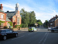
 View along the A21 towards Hastings with the old courthouse on the left | |
Location within East Sussex | |
| Area | 10.4 km2 (4.0 sq mi) [1] |
| Population | 1,481 (Parish-2011) [2] |
| • Density | 362/sq mi (140/km2) |
| OS grid reference | TQ733271 |
| • London | 42 miles (68 km) NW |
| Civil parish |
|
| District | |
| Shire county | |
| Region | |
| Country | England |
| Sovereign state | United Kingdom |
| Post town | ETCHINGHAM |
| Postcode district | TN19 |
| Dialling code | 01580 |
| Police | Sussex |
| Fire | East Sussex |
| Ambulance | South East Coast |
| UK Parliament | |
| Website | http://www.hurstgreen-pc.gov.uk |
Hurst Green is a village and civil parish in the Rother district of East Sussex, England, and is located south of the East Sussex / Kent border at Flimwell.
The area is entirely contained within the High Weald Area of Outstanding Natural Beauty.
The village is located on the A21 road, halfway between Tunbridge Wells, Kent, in the north and Hastings in the south, approx 13 miles (20 km) each way.[3] The A265 road starts in the village at the A21, previously starting in Hawkhurst.
There is one active church in the village: the brick-built Church of England parish church, dedicated to the Holy Trinity. The Roman Catholic church of Our Lady Help of Christians is now disused and has now been converted into a community shop, which also contains the village post office.[4] The local primary school is Hurst Green CE Primary School.[5]
The settlements of Silver Hill and Swiftsden are also located within the parish.
There is an active parish council.
- ^ "East Sussex in Figures". East Sussex County Council. Retrieved 26 April 2008.
- ^ "Civil Parish population 2011". Archived from the original on 4 March 2016. Retrieved 7 October 2015.
- ^ East Sussex Community Information Service
- ^ "Community Shop Blog". www.hurstgreen.com. Archived from the original on 12 July 2011.
- ^ Hurst Green CE Primary School
